Risk management in Vaca Muerta: road-specific limits, trip by trip
A fleet operating in Vaca Muerta oilfields is monitored continuously, with speed limits configured per road and precise per-trip infraction reports — even in areas with no signal, thanks to the device's local buffer.
Results
- Continuous monitoring of every trip: duration, distance, average and maximum speed, in real time
- Speed limits configured per road inside the oilfield, not just the public route's legal limit
- Exportable infraction report classified by severity (Light / Medium / Severe), with recorded vs. allowed speed, GPS location and event duration
- Local buffer on the device: if connectivity drops, events are stored on board and synced once signal is restored, with no data loss
113.9 km and 112 minutes of driving through oilfield roads, with every speeding event classified, geolocated and timestamped — even through the stretches where signal drops out.
The challenge
Running a fleet in Vaca Muerta means moving through a mix of public routes and internal oilfield roads, each with its own speed limit — often lower than the general route because of work zones, heavy-machinery crossings, or unpaved terrain. On top of that, cell coverage across the oilfield is inconsistent, and a monitoring system that depends on a constant connection loses exactly the data that matters most, in exactly the stretches where risk is highest. Managing risk in this kind of operation — and answering to an operator or an audit — requires a precise, road-by-road record that doesn't depend on having signal at all times.
The MyKeego solution
- Speed limits per road: the system doesn't apply a single fleet-wide limit — it uses maximum speeds configured per road segment, reflecting the actual rules of each road inside the oilfield.
- Trip-by-trip reporting: every trip is logged with duration, distance, average and maximum speed, plus a severity-classified event breakdown.
- Raw data export for auditing: every speeding event is classified, with recorded speed, the allowed speed at that specific point, GPS coordinates and exact event duration — ready to report to an operator or to compliance.
- Buffer for connectivity loss: if the vehicle loses signal, events are stored on the device and synced automatically as soon as the connection comes back. No event is lost to a coverage gap.
One real trip, measured
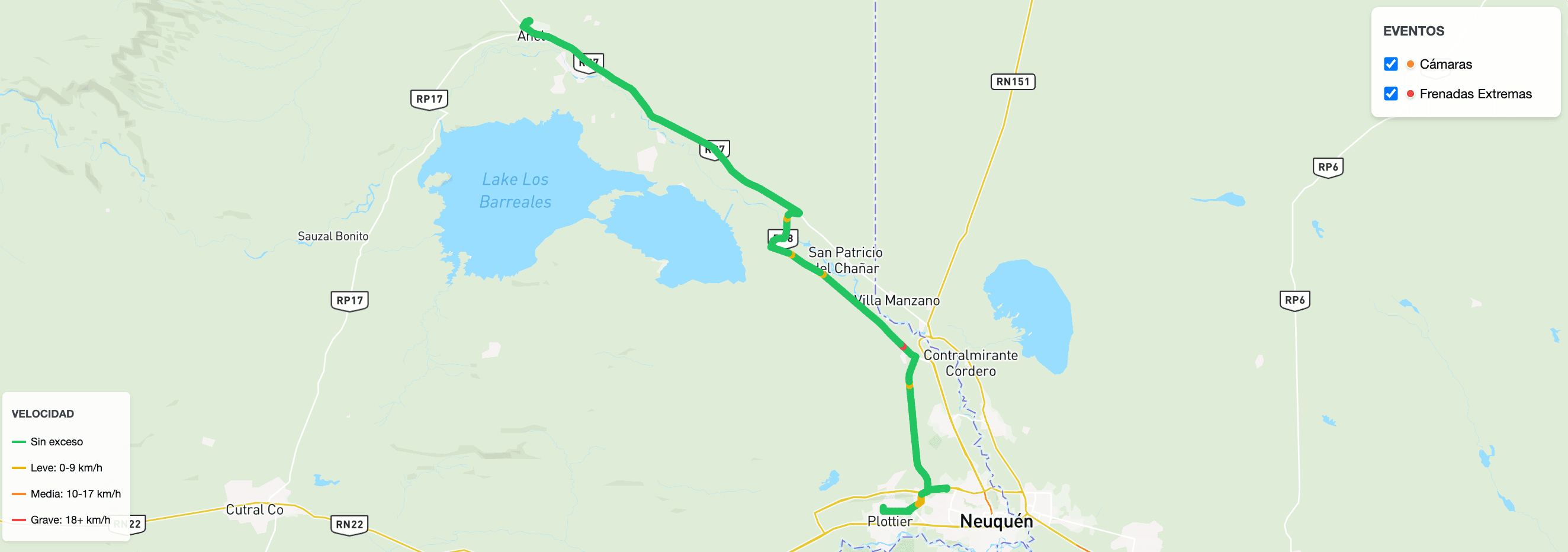
Here's what a single-trip report looks like (Unit U-452), across roads connecting Añelo, San Patricio del Chañar and Neuquén:
| Metric | Value |
|---|---|
| Duration | 112 min |
| Distance | 113.9 km |
| Average speed | 61 km/h |
| Maximum speed | 111 km/h |
| Extreme braking | 0 |
| Severe speeding | 0 |
| Moderate speeding | 0 |
| Light speeding | 1 |
The trip map colors each stretch by speeding severity and marks the location of every event — extreme braking and camera checkpoints included — over the actual route driven.
Raw data for auditing
Every infraction is classified against explicit rules:
- Light: speeding greater than 0 km/h and less than 10 km/h.
- Medium: speeding between 10 km/h and 20 km/h.
- Severe: speeding greater than 20 km/h.
A real excerpt from the exportable report, with plates anonymized:
| Date and time | Unit | Classification | Recorded speed | Allowed speed | Duration |
|---|---|---|---|---|---|
| 07/08/2026 18:35 | U-207 | Medium | 59 km/h | 40 km/h | 00:02:41 |
| 07/08/2026 18:38 | U-207 | Medium | 60 km/h | 40 km/h | 00:00:31 |
| 07/08/2026 17:51 | U-330 | Medium | 75 km/h | 60 km/h | 00:00:58 |
The 40 km/h and 60 km/h limits in the same table aren't an error: they're two different stretches of the oilfield, each with its own configured maximum. That's the difference between measuring against a generic limit and measuring against each road's actual rule.
More than a monthly report
In an operation like Vaca Muerta, where signal coverage isn't guaranteed and speed rules change from one road to the next within the same oilfield, risk management needs data that doesn't get lost and that reflects the actual road, not a fleet-wide average. MyKeego configures per-road limits and infraction reporting to fit each operation, guaranteeing that no event is lost even if a vehicle spends hours without signal.